Climate & Weather Events — 2008
No disaster casualty, damage or burned-area figures are used. The ice ranking is relative to the satellite record as known in 2008.
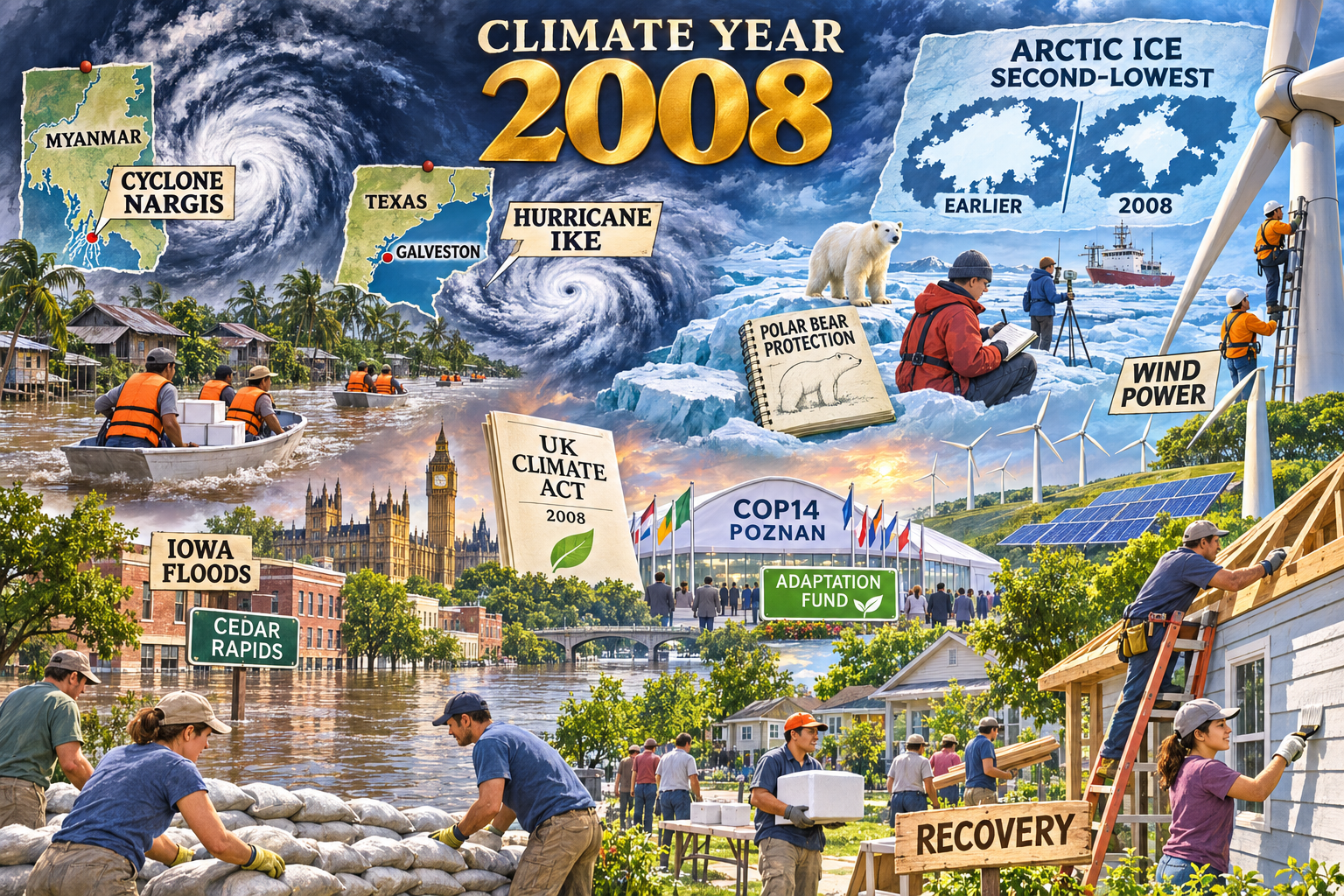
Climate & Weather Events: 2008
Model: built-in gpt-image
Generation date: 2026-11-03
Saved image path:
My-Library/Images/Collections/Climate-Weather-Events/Images/Climate-Weather-Events_2008.pngYear: 2008
Selected moments
| Moment | Why selected / visual depiction | Source |
|---|---|---|
| Cyclone Nargis, Myanmar | Defining delta disaster; storm spiral and mapped Irrawaddy delta, relief boats instead of suffering | https://science.nasa.gov/earth/earth-observatory/heavy-rain-from-cyclone-nargis-8727/ |
| Hurricane Ike, Caribbean and Texas | Major hurricane and coastal surge event; mapped coast and Galveston rebuilding | https://www.nhc.noaa.gov/data/tcr/AL092008_Ike.pdf |
| Iowa / Midwest floods | Historic inland flooding balances the cyclone focus; waterline and sandbag crews | https://www.usgs.gov/publications/floods-may-and-june-2008-iowa |
| Arctic sea-ice minimum | Second-lowest satellite-era minimum at the time, not an all-time record; ice field, comparison outline and scientists | https://science.nasa.gov/earth/earth-observatory/arctic-sea-ice-reaches-annual-minimum-9115/ |
| Polar bear threatened listing | Connects habitat science to conservation policy; healthy bear on ice and field notebook | https://www.adfg.alaska.gov/index.cfm?adfg=specialstatus.fedsummary&species=polarbear |
| US wind power growth | Record annual additions offer an energy-transition counterpoint; onshore turbines and technicians | https://www1.eere.energy.gov/wind/pdfs/46026.pdf |
| UK Climate Change Act | Major national climate-policy milestone; a titled document and parliamentary silhouette | https://www.legislation.gov.uk/ukpga/2008/27/contents/enacted |
| COP14 Poznan / Adaptation Fund | International adaptation governance; delegates and an adaptation plan, not a claim that funding ended disasters | https://unfccc.int/documents/5563 |
| Community recovery and flood response | Gives practical response substantial space; volunteers, supplies, repairs and embankments, treated as an illustrative composite rather than a documented photograph | https://www.weather.gov/dvn/flood2008 |
Research and tone notes
No disaster casualty, damage or burned-area figures are used. The ice ranking is relative to the satellite record as known in 2008. The UK Act is grounded in its original enacted version, avoiding later amendments. Poznan's Adaptation Fund decision is a governance milestone, not an assertion that every operational step was finished in 2008. Individual storms are historical events; this montage makes no event-attribution claim. Recovery scenes are generic editorial composites. No injuries, bodies, panic or agency seals are requested.
Readable labels requested
2008; CYCLONE NARGIS; MYANMAR; HURRICANE IKE; GALVESTON; IOWA FLOODS; ARCTIC ICE; SECOND-LOWEST; POLAR BEAR PROTECTION; WIND POWER; UK CLIMATE ACT; COP14 POZNAN; ADAPTATION FUND; RECOVERY.
Final Prompt Used
Use case: illustration-story
Asset type: year-by-year climate and weather events collection image
Primary request: Create a respectful illustrated environmental-editorial montage for the year 2008, showing the extreme weather events, climate-science findings, energy transitions, conservation stories, and environmental policy changes that defined that year.

Scene/backdrop: one cohesive landscape that flows across the frame from weather to response — a sky holding a storm spiral or heat haze seen from above like a weather map, a large wall map with pinned locations, an unnumbered sea-ice comparison diagram integrated into the scene, wind farms and solar fields on a ridge, a flooded street or cracked drought field,  scientists with instruments on ice or a research ship, and a neighbourhood rebuilding in the foreground. One unified world, not disconnected stickers.

Subject: combine these selected moments into one unified illustrated montage: Cyclone Nargis crossing Myanmar's Irrawaddy delta, shown as a labeled map and storm spiral with orderly relief boats; Hurricane Ike affecting the Caribbean and Texas, shown on a second clearly distinct mapped coast and volunteers rebuilding near Galveston; historic Iowa and Midwest river floods, represented by a Cedar Rapids waterline and calm sandbag crews; Arctic sea ice reaching the second-lowest minimum of the satellite record at that time, represented by field scientists, broken ice and a comparison outline; polar bears listed as threatened in the United States, represented by a small healthy bear in intact ice habitat near a conservation field notebook; record US onshore wind capacity additions, represented by turbines and maintenance technicians; the UK Climate Change Act 2008, represented by a short titled policy document and parliamentary silhouette; COP14 Poznan and its Adaptation Fund decision, represented by an international meeting pavilion and a labeled adaptation plan; community flood and cyclone recovery, represented by volunteers repairing homes, stacking supplies and improving embankments. Represent disasters through maps, storm systems, landscapes, and the people responding to them — never through injury or panic.

Year text requirement: include clear readable text in the image that says:
"2008"

Optional title text: include a short readable title such as:
"CLIMATE YEAR 2008"

Style/medium: polished cartoon-editorial illustration in a science-magazine feature style — clean linework, rich painterly detail, infographic touches (map pins, chart lines, isobars), magazine-quality digital art.

Composition/framing: wide landscape image, one unified scene rather than separate panels. Foreground: responders, scientists, and community recovery. Midground: the year's 2-3 defining events, most prominent. Background: weather systems, maps, and charts woven into the sky and landscape.

Lighting/mood: serious but hopeful — dramatic weather light on one side resolving into clear light over recovery and clean-energy scenes.

Color palette: era-aware and event-driven — storm slate blues, warm amber recovery light, floodwater browns, drought ochres, balanced by fresh greens and clear sky blues for conservation and renewables. Avoid a one-note palette.

Text constraints: short readable labels are allowed on maps, charts, signs, and instruments. Use 1-5 words per label. Keep text high-contrast, correctly spelled, and large enough to read. Do not use long captions, fake paragraphs, or a row of labels at the bottom.

Avoid: gore, bodies, injured people, panic or screaming crowds, disaster-movie spectacle, exact logos and agency seals, photorealistic likenesses of real people, hateful symbols, cluttered sticker-collage layout, tiny unreadable labels, distorted lettering, fake full article text, watermarks, signatures, borders, and generic stock imagery.

Match Climate & Weather Events 2006 and 2007 siblings: detailed painterly cartoon-editorial science illustration, clean linework, large gold year at the upper center, storm-map blues, brown floodwaters, crisp Arctic cyan, and hopeful recovery greens. Seamlessly interweave the environmental vista, mapped global events and foreground responders with atmospheric transitions; no rigid panels. Largest anchors are Nargis, Ike and Arctic ice; at least one-third of the composition is science, wind energy, conservation, policy and recovery. No casualty figures or unsourced temperature rankings. Readable short labels only: 2008, CYCLONE NARGIS, MYANMAR, HURRICANE IKE, GALVESTON, IOWA FLOODS, ARCTIC ICE, SECOND-LOWEST, POLAR BEAR PROTECTION, WIND POWER, UK CLIMATE ACT, COP14 POZNAN, ADAPTATION FUND, RECOVERY. Output landscape 1536 by 1024 pixels.
Correction for this render: use completely unmarked relief boats, white supply boxes and plain orange life jackets. No cross emblems, no red cross, no medical symbols, no agency marks, no official seals or coat of arms. The UK policy document is plain type with a generic leaf, no coat of arms. Do not include a temperature chart, rising temperature line, thermometer, wildfire or firefighters: these were extraneous unsupported additions. Keep the sourced Arctic comparison labeled EARLIER and 2008, without numerical axes; it is illustrative, not measured geometry. Treat mapped locations as distinct simplified insets with clear coastlines, never merging Myanmar with Texas. The warm dramatic sky is weather lighting, not fire.
Visual QA
Compared with 2006 and 2007 siblings: large gold year, painterly cartoon-editorial detail, mapped storms, Arctic science and foreground community activity match the established framing and finish. The saved image has a readable 2008 and short correctly spelled labels. Nargis, Ike and Arctic ice anchor the scene, while wind power, conservation, UK policy, Poznan adaptation governance and recovery occupy substantial space. Calm responders and generic figures; no gore, injury, panic, recognizable real people, logos, agency seals or watermark observed. A first render was rejected because it introduced a red-cross emblem, an unsourced temperature graph and an unrelated wildfire. The accepted second render removes those defects. The ice comparison and location maps are schematic illustrations, not measured cartography; the view combines separate places through an editorial montage. Solar panels are supporting clean-energy scenery, not a claimed 2008 solar milestone. Final readable labels additionally include CLIMATE YEAR, TEXAS, CEDAR RAPIDS and EARLIER; GALVESTON appears on its map. Saved as a non-empty 1536x1024 PNG.
More from Image Collections