Image Collections
Lost Cities of Antiquity — Atlantis
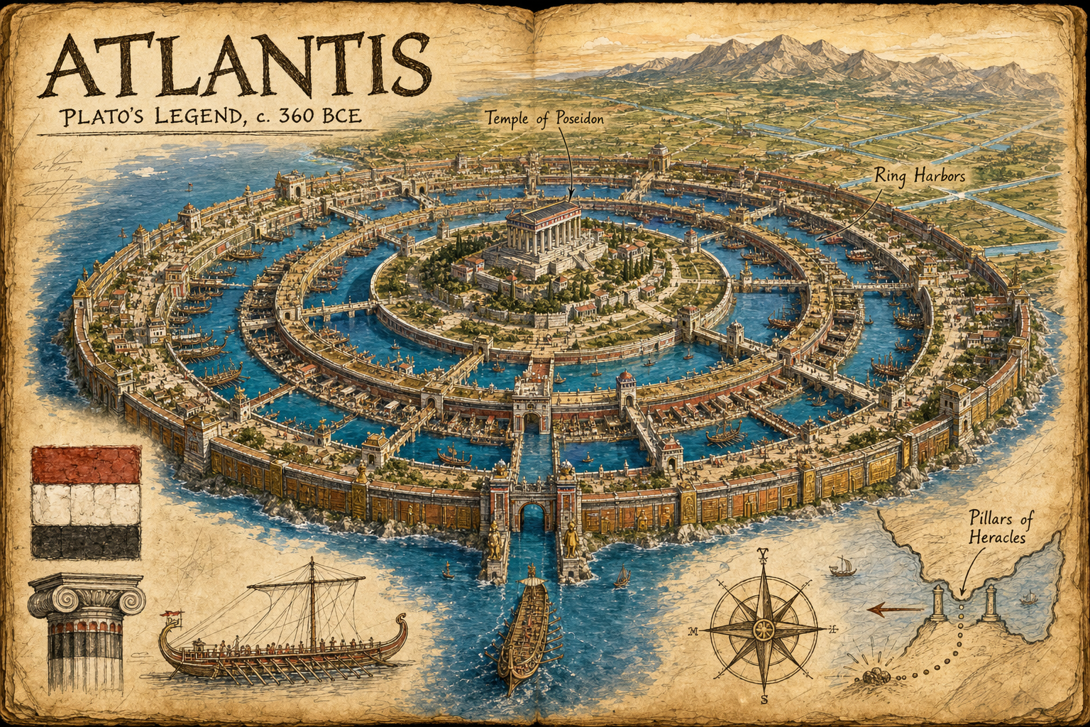
Atlantis is a legendary island civilization described by Plato in Timaeus and Critias, composed around 360 BCE.
Atlantis
- Entry slug:
Atlantis - Lost city: Atlantis
- Civilization / era: Legendary island civilization described by Plato, c. 360 BCE
- Modern-day setting: Fabled island beyond the Pillars of Heracles in the Atlantic Ocean, per Plato
- Presentation: Original splendor. Because Atlantis has no verified archaeological site or rediscovery, the illustration treats it as a luminous, romanticized legend while grounding the city plan and architecture in Plato's descriptions.
- Saved image:
My-Library/Images/Collections/Lost-Cities/Images/Lost-Cities_Atlantis.png - Model: built-in gpt-image
- Generation date: 2026-07-25
Historical and rediscovery summary
Atlantis is a legendary island civilization described by Plato in Timaeus and Critias, composed around 360 BCE. In Plato's story it ruled an extensive maritime power beyond the Pillars of Heracles before earthquakes and floods caused the island to sink into the sea. It has no verified geographical location, excavated remains, or historical rediscovery; the metadata and image therefore frame it as Plato's legend rather than an archaeological fact.
Selected visual details
- Three concentric seawater rings alternating with two land rings around the central hill: the most distinctive element of Plato's city plan and the image's primary visual signature.
- A central Temple of Poseidon and royal palace: anchors the sacred and political core described in Critias.
- A broad canal connecting the outer ring harbor to the ocean, with bridges, towers, gates, triremes, and docks: communicates Atlantis as a maritime capital and follows Plato's account of navigable passages.
- Red, white, and black quarried stone with brass, tin, and reddish metallic wall accents: adds the unusual material palette explicitly described by Plato.
- Hot and cold springs, fountains, gardens, and groves: represents the abundant waterworks and cultivated sanctuary landscape in the account.
- A fertile plain crossed by straight irrigation canals and sheltered by mountains: establishes the island's wider geographical setting rather than showing only a generic circular city.
- A corner map of the Pillars of Heracles pointing west into the Atlantic: makes the legendary geographical claim clear without implying a known location.
Sources
- Plato, Critias, Internet Classics Archive, MIT: https://classics.mit.edu/Plato/critias.html
- Plato, Timaeus 25, Scaife Viewer / Perseus Digital Library: https://scaife-reader.perseus.tufts.edu/reader/urn:cts:greekLit:tlg0059.tlg031.perseus-eng2:25
- World History Encyclopedia, "Atlantis": https://www.worldhistory.org/atlantis/
Final prompt used
Use case: illustration-story
Asset type: Lost Cities of Antiquity collection entry, 3:2 landscape PNG
Primary request: Create a polished cartoon-editorial illustration of legendary Atlantis as one cohesive archaeological sketchbook / explorer travel-journal page, showing the city in romanticized original splendor, grounded specifically in Plato's Timaeus and Critias rather than asserting a real archaeological discovery.
Scene/backdrop: An aged parchment journal spread with one dominant central ink-and-watercolor aerial vista of a luminous island metropolis beyond the Pillars of Heracles in the Atlantic. A fertile rectangular coastal plain meets steep mountains and a deep blue ocean under golden, slightly dreamlike expedition light. The metropolis is organized around a low central hill with exactly three concentric seawater rings alternating with two land rings, joined by bridges and a broad ship canal to the sea.
Anchor structures: a grand central Temple of Poseidon and royal palace on the innermost island; ring harbors crowded with generic ancient triremes and docks carved into rock; bridges with towers and gates spanning the circular channels.
Researched visual details: alternating red, white, and black quarried stone masonry; outer walls gleaming in brass, tin, and reddish orichalcum-like metal; hot and cold springs feeding baths and fountains; gardens and groves around the sanctuary; straight irrigation canals crossing the fertile plain; mountains sheltering the plain from the north. Keep the design a source-grounded ancient Mediterranean fantasy, not futuristic science fiction.
Margins/map: In the lower corner, include a hand-drawn compass rose and small map sketch of the Strait of Gibraltar / Pillars of Heracles with an arrow pointing west into the Atlantic and a clearly mythical island marker. Add only a few small field-sketch accents: a red-white-black masonry swatch, a trireme profile, and a column-capital study. The page must feel unified, not like stickers or separate panels.
Text (verbatim): Large, high-contrast, correctly spelled hand lettering: "ATLANTIS". Directly beneath it, smaller clear hand lettering: "PLATO'S LEGEND, c. 360 BCE". Optional labels limited to these short phrases: "Ring Harbors", "Temple of Poseidon", "Pillars of Heracles".
Style/medium: polished magazine-quality cartoon editorial illustration; archaeological sketchbook; expressive sepia ink linework, transparent watercolor washes, aged paper texture, subtle handwritten field-note marks. Warm expedition-journal charm, stylized and illustrative, never photorealistic.
Composition/framing: wide 3:2 landscape, 1536x1024 intent. The Atlantis vista dominates the page and remains recognizable at thumbnail size; compass map occupies one corner; strong visual hierarchy and generous margins.
Palette: parchment cream, sepia ink, Atlantic cobalt and turquoise, volcanic blue, fertile green, red/white/black stone, warm copper and gold accents.
People: only tiny generic stylized citizens, sailors, traders, and builders; no identifiable historical or modern person.
Constraints: spell all required text exactly; visibly show the concentric-ring plan and sea canal; clearly frame Atlantis as legend through the era line and dreamlike rendering.
Avoid: photorealism, real-person likenesses, modern objects, modern buildings, sci-fi towers, domes or technology, exact logos, fake paragraphs, long captions, gibberish text, distorted lettering, cluttered collage, generic ruins, graphic violence, watermark.
More from Image Collections

Internet Culture Timeline — 2025
2025-01-01

Music Yearbooks — 2025
2025-01-01

News & Culture — 2025
2025-01-01

NFL Super Bowls — 2025
2025-01-01

Science Breakthroughs — 2025
2025-01-01
Transportation & Mobility — 2025
2025-01-01

Video Game History — 2025
2025-01-01

Internet Culture Timeline — 2024
2024-01-01
Music Yearbooks — 2024
2024-01-01

News & Culture — 2024
2024-01-01

NFL Super Bowls — 2024
2024-01-01
Science Breakthroughs — 2024
2024-01-01