Mount St. Helens Crater Stepped Relief Wall Map
A landscape-format framed contour relief of Mount St. Helens and its open crater, built from public USGS elevation data, for anyone who wants the 1980 eruption's shape on the wall as terraces of…
Mount St. Helens Crater Stepped Relief Wall Map
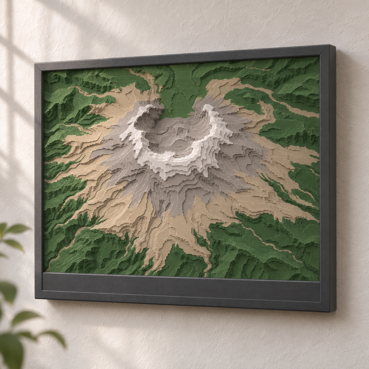
A landscape-format framed contour relief of Mount St. Helens and its open crater, built from public USGS elevation data, for anyone who wants the 1980 eruption's shape on the wall as terraces of colour.
Date: 2026-11-10 Category: Art and Decor Modeling difficulty: Intermediate Estimated print: ~12 h total · ~190 g PLA (estimate; tile ~6 h and ~85 g, frame ~6 h and ~105 g) Suggested price: $45–$65 printed · $12 digital file (estimate) Status: Concept
Description
Mount St. Helens Crater Stepped Relief Wall Map is a 3:2 landscape plaque. The tile covers a 30 km × 20 km window around the volcano and turns the terrain into ten flat contour bands, each 1.2 mm tall and standing for 200 m of elevation. Four colours carry the height: forest green for the valleys, stone tan for the lower slopes, warm grey for the upper cone and white for the summit rim.
The tile presses into a charcoal frame with a 24 mm title band along the bottom, where a place name can be raised in white. Two hidden keyholes on the back hang it on screws. The tile stands 5 mm above the rim so the terrace edges catch side light, and the horseshoe crater opening to the north reads as a notch in the white band.
The shape is not traced from a picture. The Modeling guide builds the tile from the USGS 3D Elevation Program DEM, and the band rule is exact enough to repeat for any other peak. The cover image is a mood image only; the terrain comes from the dataset.
Why it sells
This is an art idea, chosen on taste and not on sales rankings. What it relies on is the data: USGS states on its 3D Elevation Program page that all 3DEP products are free and without use restrictions, and the data.gov catalog entry for the 1/3 arc-second DEMs is the tile source. The USGS general information product on the volcano gives the summit as 2,539 m (8,330 ft), which sets the top of the band scale. The gap this fills: the owner's Crater Lake, Grand Canyon and Rainier maps are lake, canyon and round-disc pieces; this one is the first landscape tile and the first with a crater that is open on one side.
Who buys it
Hikers and road-trippers who have visited the monument, Pacific Northwest locals, geology and volcano fans, and owners of multicolour printers who want a wall piece. Sold on Etsy, at craft markets, and in park-town gift shops.
Design overview
- Ten 1.2 mm contour bands at a 200 m interval, datum 600 m, so the band 10 top sits at 2,600 m, above the 2,539 m summit.
- Four tile colours (forest green, stone tan, warm grey, white), which fits one four-slot AMS with no spool swap.
- A 0.1 mm per side press fit holds the tile in the frame, and the tile stands 5 mm proud so the steps read in side light.
- Landscape 180 × 120 mm tile at 1 mm per 166.7 m, so a pixel in the heightfield is one mm on the print.
- Title band with raised, two-line text that can be changed per order.
- Differentiator: the horseshoe crater and the Toutle valley it opens into show as a clear notch, which a rounded map would crop out.
Dimensions
| Measurement | Value (mm) | Notes |
|---|---|---|
| Overall width (X) | 196 | frame |
| Overall depth (Y) | 152.2 | frame, including the 24 mm title band |
| Overall height (Z) | 21 | frame 16 plus tile standing 5 above the rim |
| Wall thickness | 7.9 | frame rim at the sides, 8.0 at the top |
| Tile | 180 × 120 × 14 | 2.0 base + 10 bands of 1.2 |
| Contour interval | 200 m of elevation = 1.2 mm of height | datum 600 m, bands 600 to 2,600 m |
| Map window | 30 km × 20 km | 1:166,700 both ways, so no vertical exaggeration (1.2 mm per 200 m) |
| Tile pocket | 180.2 × 120.2 × 9 | 0.1 per side |
| Frame floor | 7 | behind the tile; holds the keyhole cavities |
| Keyhole lip / cavity / roof | 1.6 / 3.6 / 1.8 | entry 8 dia, slot 4.2 wide × 8 long, cavity 8.4 wide; at X = 48 and 148, Y = 115 |
| Title text | 9 and 4 tall, raised 0.6 | blank until personalised |
Parts list
| Part | Qty | Material | Size X×Y×Z (mm) | Print orientation | Supports |
|---|---|---|---|---|---|
| Relief tile | 1 | PLA | 180×120×14 | Base down, flat on the bed | none |
| Frame with title band | 1 | PLA | 196×152.2×16.6 | Back face down, flat on the bed; raised title text prints last on the top face | none |
Hardware and non-printed parts
- No. 6 pan-head wood screw, 25 mm (head 7.5 mm dia and no thicker than 3.2 mm, shank 3.8 mm) ×2: driven into the wall 100 mm apart; the frame hangs on the keyholes
- Two-part epoxy or cyanoacrylate, 1 drop ×1: optional, a spot at each pocket corner
Fits and tolerances
- Relief tile into frame pocket: press fit, 0.1 mm per side (pocket 180.2 × 120.2 mm for a 180 × 120 mm tile). Tile lower edges are chamfered 0.4 mm so first-layer flare does not jam.
- Screw into keyhole: the 8 mm entry and 8.4 mm cavity pass a head up to 7.5 mm dia and 3.2 mm thick; the 4.2 mm slot passes a shank up to 3.8 mm. Loose hanging fit.
Modeling guide
Origins and axes are given in step 1 of each part. Tile first.
Relief tile:
- Prepare the heightfield outside CAD: download the USGS 3DEP 1/3 arc-second DEM for a 30 km × 20 km window centred near 46.20 N, 122.19 W (check the centre against the summit in the DEM and shift it so the crater sits at X = 90 mm, Y = 60 mm). Resample to 180 × 120 pixels (1 pixel = 1 mm = about 166.7 m of ground).
- Quantize with n = clamp(floor((elev_m - 600) / 200) + 1, 1, 10). For each n export the polygon where elev_m >= 600 + 200 * (n - 1), smoothed with a 1 mm radius, dropping islands smaller than 2 mm across.
- Sketch on XY, origin at the tile's lower-left corner: rectangle 180 × 120. Extrude 2.0 (base).
- Extrude polygon n by 1.2 from z = 2.0 + 1.2 * (n - 1), so polygon 1 starts at z = 2.0 and polygon 10 at z = 12.8. Final top at z = 14.0.
- Chamfer the lower perimeter edge 0.4.
- Split into colour bodies: z 0-4.4 forest green (base, bands 1-2), 4.4-8.0 stone tan (bands 3-5), 8.0-11.6 warm grey (bands 6-8), 11.6-14.0 white (bands 9-10).
Frame with title band:
- Origin: lower-left corner of the back face. +X right, +Y up the wall, +Z out from the wall. Sketch on XY: rectangle 196 × 152.2, corner radius 3. Extrude 16.
- Cut the tile pocket from the front face: rectangle 180.2 × 120.2, lower-left corner at X = 7.9, Y = 24.0. Depth 9, leaving a 7 mm floor.
- Fillet the outer front edge 1.0.
- Keyholes at (X = 48, Y = 115) and (X = 148, Y = 115), cut from the back face in two layers. Lip layer, z = 0 to 1.6: a circle 8 dia plus a slot 4.2 wide from the circle centre up to Y = 123. Hidden head cavity, z = 1.6 to 5.2: a circle 8.4 dia plus a channel 8.4 wide from the centre up to Y = 123. That leaves a 1.8 mm roof (z = 5.2 to 7).
- Title text raised 0.6 on the front face of the bottom band (z = 16 to 16.6): line 1 height 9 mm, centred at X = 98, Y = 14; line 2 height 4 mm, centred at X = 98, Y = 5. Bold sans font, white from z = 16.0.
Print settings
| Setting | Value |
|---|---|
| Material | PLA (matte). Four colours for the tile, charcoal for the frame, white for the title text. |
| Nozzle | 0.4 mm |
| Layer height | 0.2 mm |
| Walls / perimeters | 4 |
| Infill | 15% gyroid |
| Supports | none |
| Brim / adhesion | brim 5 on the frame; none on the tile |
| Notes | Colour changes on the tile at z = 4.4, 8.0 and 11.6. Print the tile base-down. Bands narrower than 2 mm are removed in the modeling step to avoid weak lines. |
Assembly
- Press the tile into the frame pocket, base down, until it seats.
- Optional: one drop of glue at each pocket corner.
- Drive two screws into the wall 100 mm apart, leave 5.0 mm between the wall and the underside of each head, and hang the frame on the keyholes.
Variants and upsells
- Other peaks with the same frame: Mount Hood, Mount Adams, Mount Shasta (check the summit height for the datum each time).
- A 120 × 80 mm desk version with a 20 km × 13.3 km window and 8 bands.
- A personalised title line (a hike date, coordinates).
- A series: every map in the same 196 mm frame so a set hangs in a row.
Selling and distribution
Etsy and local gift shops suit a printed piece; MakerWorld and Printables suit the file under a commercial licence. Price from material (about 190 g), roughly 12 h of printer time, and a margin, which lands near $45 to $65 printed; the file is a $12 estimate. Put the credit in the listing: "Elevation: U.S. Geological Survey 3D Elevation Program." USGS asks for no credit on 3DEP data, but a credit line costs nothing; do not imply USGS endorses the product.
Keywords: Mount St. Helens art, volcano wall art, topographic map art, 3D printed relief map, contour map decor, Washington gift, Pacific Northwest decor, hiking gift, layered map, multicolour 3D print, national monument gift, geology gift.
Risks and IP notes
- Thin bands near the crater rim (under 2 mm wide) can print poorly. Mitigation: the 1 mm smoothing and 2 mm island filter in step 2.
- Colour count: four tile colours need one AMS. Mitigation: bands 1-2 and 9-10 are the only ones that need unusual spools; a three-colour version drops grey.
- Market: other sellers list volcano maps. Mitigation: the frame, the landscape crop and the series.
- IP: use the credit line above and avoid the USGS name in the product title.
Resource links
- USGS 3D Elevation Program — Publisher page: all 3DEP products free and without use restrictions; the DEM to build from
- USGS 1/3 arc-second DEMs, data.gov catalog entry — The dataset record for the 10 m tiles used for the tile
- USGS general information product 262, Mount St. Helens — Publisher document giving the summit as 2,539 m (8,330 ft)
More from 3D Print Designs