Yosemite Valley Landscape Stepped Relief Wall Map
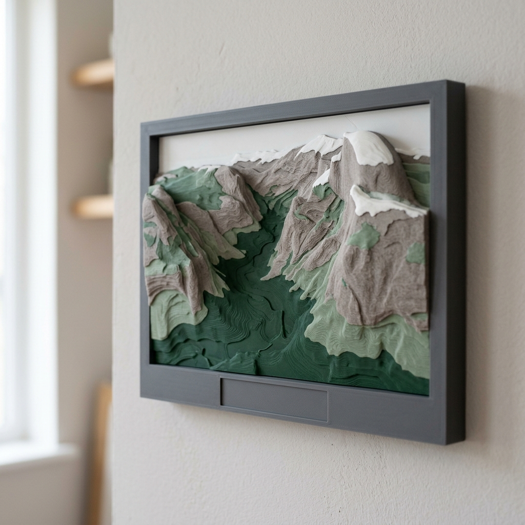
A 210 × 150 mm landscape wall map of Yosemite Valley and Half Dome, cut into ten colour bands from public USGS elevation data, with a swap-in title plate.
Yosemite Valley Landscape Stepped Relief Wall Map
A 210 × 150 mm landscape wall map of Yosemite Valley and Half Dome, cut into ten colour bands from public USGS elevation data, with a swap-in title plate.
Date: 2026-11-11 Category: Art and Decor Modeling difficulty: Intermediate Estimated print: ~14 h total · ~195 g PLA (estimate) Suggested price: $45–$85 printed · $9 digital file (estimate) Status: Concept
Description
A flat frame, 210 mm wide and 150 mm tall, 22 mm deep. Inside a 10 mm rim sits a 190 × 110 mm window of terrain, cut into ten steps that are each 1.6 mm taller than the last. The window covers a 28.5 × 16.5 km stretch of the Sierra Nevada with the valley running through the middle and Half Dome near the centre. Glacier-cut granite walls are steep, so the steps stack tightly on the valley sides and spread out on the floor.
Filament changes at three fixed heights turn the steps into a colour gradient: forest green on the valley floor, sage, warm granite grey, then white on the highest caps. A 120 × 14 mm title plate presses into a pocket under the window. Two keyhole slots on the back hang it on wall screws.
The terrain is not drawn or traced. It comes from the USGS 3D Elevation Program, and the modeling guide gives the tile, window, scale and banding so anyone can rebuild it from the data. The cover is a mood image; the geometry comes from the dataset.
Why it sells
This is an art piece chosen on taste, so there is no sales evidence to cite and I did not find any specific to multicolour 3D-printed maps. What I can source is the data side: USGS says all 3DEP products are available free of charge and without use restrictions, and its catalog entry for the 1/3 arc-second DEM is the dataset to build from. The National Park Service geology page describes the glacier-carved valley and granite domes that make this terrain read well as steps. The gap this fills is a landscape-format piece in a library whose other maps are square or round, and Yosemite is not yet in the set.
Who buys it
Hikers and climbers who have walked the valley, and people buying for them. The finished print suits Etsy or a craft market; the file with the DEM recipe suits owners of a multicolour printer. It hangs beside the library's other relief maps as a mixed set.
Design overview
- 210 × 150 mm frame, 22 mm deep, 10 mm rim at the sides and top, 30 mm at the bottom for the plate.
- 190 × 110 mm terrain window at 1 mm = 150 m, ten bands at 1.6 mm over a 5 mm floor.
- Colour changes at z = 8.2, 13.0 and 17.8 mm, all on 0.2 mm layer boundaries, so a plain pause-and-swap works.
- Press-fit title plate, 120 × 14 mm, 0.15 mm clearance per side. This is what makes the frame reusable.
- Two back keyholes 80 mm apart for flat hanging.
- Elevation source: USGS 3DEP 1/3 arc-second DEM, tile n38w120, public domain. Credit line: "Data available from U.S. Geological Survey, National Geospatial Program".
Dimensions
| Measurement | Value (mm) | Notes |
|---|---|---|
| Overall width (X) | 210 | Frame |
| Overall depth (Y) | 150 | Frame height on the wall |
| Overall height (Z) | 23 | Frame 22 plus 1 mm raised plate text |
| Wall thickness | 10 | Minimum rim (sides and top) |
| Terrain window | 190 × 110 | X 10 to 200, Y 30 to 140 |
| Floor height | 5 | Terrain floor, z |
| Band step | 1.6 | Ten bands, top at z = 21.0 |
| Title pocket | 120.3 × 14.3 | X 44.85 to 165.15, Y 8 to 22.3, 3 deep |
| Keyhole head diameter | 9 | At (65, 110) and (145, 110), 3.5 deep |
| Keyhole slot | 4.5 × 8 | Toward +Y |
Parts list
| Part | Qty | Material | Size X×Y×Z (mm) | Print orientation | Supports |
|---|---|---|---|---|---|
| Relief frame with terrain | 1 | PLA | 210 × 150 × 22 | Back face down | none (keyhole recesses bridge 9 mm) |
| Title plate | 1 | PLA | 120 × 14 × 4 | Flat, text up | none |
Hardware and non-printed parts
2 × wall screws, pan head, 4 mm shank, 8 mm head. The heads sit in the Ø9 keyhole recesses.
Fits and tolerances
- Title plate in pocket: press fit, 0.15 mm per side (inside the 0.1–0.15 mm press range). The plate is only 3 mm deep in the pocket, so add a dot of glue before shipping.
- Keyholes: 4.5 mm slot for a 4 mm shank, 0.25 mm per side, sliding.
Modeling guide
Origin: lower-left corner of the back face. +X right along the long side, +Y up the wall, +Z out toward the viewer.
Relief frame
- Sketch on XY: rectangle 210 × 150 from the origin. Extrude +Z 22.
- On the top face (z = 22) sketch a rectangle X 10 to 200, Y 30 to 140. Cut down 17 to z = 5.
- On the top face sketch a rectangle X 44.85 to 165.15, Y 8 to 22.3. Cut down 3 to z = 19.
- Get the DEM: download USGS 3DEP 1/3 arc-second tile n38w120 from The National Map. The window runs lat 37.666 to 37.814 N, lon 119.712 to 119.388 W, centred on 37.740 N, 119.550 W, so one tile covers it.
- Resample to a 0.2 mm grid over the window (1 mm = 150 m). Apply one 3 × 3 median filter. Quantise to 10 bands: band = min(9, floor(10 × (elevation − min) ÷ (max − min))), with min and max taken inside the window.
- Band b has top height z = 5 + 1.6 × (b + 1). Extrude each band's region from z = 5 to that height. Simplify outlines at 0.4 mm tolerance and delete islands smaller than 1.2 × 1.2 mm.
- Check vertical exaggeration: 16 ÷ ((max − min elevation in metres) ÷ 150). Expect 1.0 to 1.3. Over 2.0 the steps get too tall and thin.
- On the back face cut two keyholes at (65, 110) and (145, 110): a Ø9 recess 3.5 deep, then a 4.5 wide slot 8 long toward +Y, 3.5 deep.
- Fillet the outer top edge 0.8 and chamfer the bottom outer edge 0.4.
Title plate (origin at the centre of its bottom face)
- Sketch a 120 × 14 rectangle centred on the origin. Extrude 3.
- Emboss the title in a bold sans-serif, cap height 7, 1.0 high, centred. Default text: YOSEMITE VALLEY. Keep strokes at least 1.2 wide.
- Chamfer the bottom perimeter edge 0.3.
Print settings
| Setting | Value |
|---|---|
| Material | PLA (matte; silk or bright white for the caps) |
| Nozzle | 0.4 mm |
| Layer height | 0.2 mm |
| Walls / perimeters | 3 |
| Infill | 15% gyroid |
| Supports | None |
| Brim / adhesion | Brim 5 mm |
| Notes | Colour changes at z = 8.2, 13.0, 17.8 mm. The change applies to the rim too, so the frame edge shows the same four stripes, like layered strata. Print the plate separately in forest green. |
Assembly
- Press the plate into the bottom pocket.
- Set two screws 80 mm apart, level.
- Slide the frame down onto the screws through the keyholes.
Variants and upsells
- Same recipe for other valleys and ranges: swap the tile and window and the plate text.
- Pair with the library's square and round relief maps for a mixed wall.
- Personalised plate with coordinates or a visit date.
- A six-colour edition at the same 1.6 mm steps.
Selling and distribution
Etsy and craft markets suit the finished print; MakerWorld and Printables suit the file, with the DEM recipe as the selling point. Price from material (about 195 g PLA), machine time (about 14 h) and margin, which is how the $45–$85 estimate was set. Sell both. Use a commercial-use licence for the file if you charge for it. Keep the USGS credit line in the listing and on the back of the frame.
Keywords: Yosemite art, Half Dome wall art, topographic relief map, 3D printed map, stepped relief, layered map, national park gift, hiking gift, mountain decor, California gift.
Risks and IP notes
- Thin step walls can break in handling. Mitigation: 1.2 mm island minimum and 0.4 mm simplification.
- Hand filament changes cost time. Mitigation: only three changes, at fixed heights.
- Many map sellers exist. Mitigation: landscape format and the swap-in plate.
- USGS asks that data not be presented as endorsed by USGS. Mitigation: use the credit line only, no USGS logo.
- Park place names are fine; avoid National Park Service logos or the arrowhead shape.
Resource links
- USGS 3DEP 1/3 arc-second DEM catalog entry — the exact dataset to build from
- USGS 3D Elevation Program — publisher page: products free and without use restrictions
- Costs or restrictions on National Map data — public domain status and the requested credit line
- How to cite National Map data — citation wording
- Yosemite geology (National Park Service) — the glacier-carved valley and granite domes the relief shows
More from 3D Print Designs