Mount Etna Sea-to-Summit Stepped Relief Wall Map
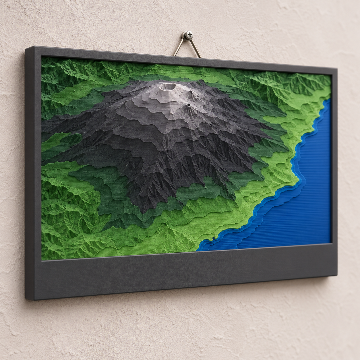
A 200 × 150 mm landscape wall map that runs from the Ionian coast to the summit craters of Mount Etna in ten colour bands, built from INGV's 10 m Italian elevation model.
Mount Etna Sea-to-Summit Stepped Relief Wall Map
A 200 × 150 mm landscape wall map that runs from the Ionian coast to the summit craters of Mount Etna in ten colour bands, built from INGV's 10 m Italian elevation model.
Date: 2026-11-12 Category: Art and Decor Modeling difficulty: Intermediate Estimated print: ~12.1 h total · ~151 g PLA (estimate) Suggested price: $45–$85 printed · $9 digital file (estimate) Status: Concept
Description
A landscape frame, 200 mm wide, 150 mm high and 22 mm deep. Inside a 10 mm rim sits a 180 × 110 mm window of terrain in ten steps, each 1.6 mm taller than the last. At 1 mm = 250 m the window covers about 45 × 27.5 km. The volcano sits left of centre and the coast runs down the right side, so the lowest bands are the sea and the Catania plain and the highest bands are the summit craters, about 3,300 m up.
Three filament changes colour the bands: blue for the sea and the lowest coast, green for the farmland and woods on the lower flanks, near-black for the lava fields, and pale grey for the ash of the summit zone. A 150 × 14 mm plate presses into a pocket under the window. Two keyholes on the back hang the frame flat on wall screws.
The terrain is not drawn or traced. It comes from TINITALY/1.1, the national 10 m elevation model published by INGV, and the modeling guide gives the window, scale and banding so anyone can rebuild it. The cover image is a mood image only. I have not run the elevation download, so the real maximum inside the window must be read at step 5 of the guide and the vertical exaggeration checked.
Why it sells
This is an art piece chosen on taste, so I did not look for sales evidence. The data side is sourced. The TINITALY page at INGV says the model has a 10 m cell size, is published under CC BY 4.0, and "must be cited". Its download area hosts version 1.1, and an EMD help page quotes a vertical RMSE of 1.98 m at Mount Etna. The gap: the library's maps so far use USGS and Copernicus data. This is the first from a national mapping source outside the US, and the first where the coastline is part of the picture, so the colour bands start at the sea.
Who buys it
Travellers and hikers who have climbed or flown past Etna, Sicilian families abroad, and gift buyers for them. The finished print suits Etsy or a craft market. The file with the DEM recipe suits owners of a multicolour or pause-and-swap printer. It hangs beside the library's other relief maps.
Design overview
- 200 × 150 mm frame, 22 mm deep, 10 mm rim at the sides and top, 30 mm at the bottom for the plate.
- 180 × 110 mm terrain window at 1 mm = 250 m, ten bands of 1.6 mm over a 5 mm floor.
- Colour changes at z = 8.2, 13.0 and 17.8 mm, all on 0.2 mm layer boundaries, so a plain pause-and-swap works.
- Press-fit title plate, 150 × 14 mm, 0.15 mm clearance per side, so the frame can be reused for other volcanoes.
- Two back keyholes 80 mm apart.
- Elevation source: TINITALY/1.1. Credit line: Tarquini S., Isola I., Favalli M., Battistini A., Dotta G. (2023). TINITALY, a digital elevation model of Italy with a 10 meters cell size (Version 1.1). Istituto Nazionale di Geofisica e Vulcanologia (INGV). https://doi.org/10.13127/tinitaly/1.1. Put it on the back and in the listing.
- The one feature that sets it apart: the sea is the lowest band, so the map shows the whole climb from the shoreline to the crater.
Dimensions
| Measurement | Value (mm) | Notes |
|---|---|---|
| Overall width (X) | 200 | Frame |
| Overall depth (Y) | 150 | Frame height on the wall |
| Overall height (Z) | 23 | Frame 22 plus 1 mm raised plate text |
| Wall thickness | 10 | Minimum rim (sides and top) |
| Terrain window | 180 × 110 | X 10 to 190, Y 30 to 140 |
| Floor height | 5 | Terrain floor, z |
| Band step | 1.6 | Ten bands, top at z = 21.0 |
| Title pocket | 150.3 × 14.3 | X 24.85 to 175.15, Y 8 to 22.3, 3 deep |
| Keyhole head diameter | 9 | At (60, 120) and (140, 120), 3.5 deep |
| Keyhole slot | 4.5 × 8 | Toward +Y, 3.5 deep |
Parts list
| Part | Qty | Material | Size X×Y×Z (mm) | Print orientation | Supports |
|---|---|---|---|---|---|
| Relief frame with terrain | 1 | PLA | 200 × 150 × 22 | Back face down | none (keyhole recesses bridge 9 mm) |
| Title plate | 1 | PLA | 150 × 14 × 4 | Flat, text up | none |
Hardware and non-printed parts
2 × wall screws, pan head, 4 mm shank, 8 mm head. The heads sit in the dia 9 keyhole recesses.
Fits and tolerances
- Title plate in pocket: press fit, 0.15 mm per side, in the 0.1–0.15 mm press range. The pocket is only 3 mm deep, so add a dot of glue before shipping.
- Keyholes: 4.5 mm slot for a 4 mm shank, 0.25 mm per side, sliding.
Modeling guide
Origin: lower-left corner of the back face. +X right (east), +Y up the wall (north), +Z toward the viewer.
Relief frame
- Sketch on XY: rectangle 200 × 150 from the origin. Extrude +Z 22.
- On the top face (z = 22) sketch a rectangle X 10 to 190, Y 30 to 140. Cut down 17 to z = 5.
- On the top face sketch a rectangle X 24.85 to 175.15, Y 8 to 22.3. Cut down 3 to z = 19.
- Get the DEM: download TINITALY/1.1 from the INGV download area. It is a GeoTIFF in UTM WGS 84 zone 32, so reproject to lon/lat before cutting. The window runs lon 14.800 to 15.311 E and lat 37.626 to 37.874 N, which puts the summit (about 37.751 N, 14.993 E) at X ≈ 46, Y ≈ 85. Check pixel alignment against the product you download.
- Set sea and nodata cells to 0 m, resample to a 0.2 mm grid (1 mm = 250 m), apply one 3 × 3 median filter, then read the window maximum. Quantise: band = min(9, floor(10 × elevation ÷ maximum)).
- Band b has top height z = 5 + 1.6 × (b + 1). Extrude each band's region from z = 5 to that height. Simplify outlines at 0.4 mm tolerance and delete islands under 1.2 × 1.2 mm.
- Check exaggeration: 16 ÷ (maximum ÷ 250). For a 3,350 m maximum it is about 1.2. If your maximum is far from that, adjust
metres_per_mm. - On the back face cut two keyholes at (60, 120) and (140, 120): dia 9 recess 3.5 deep, then a 4.5 wide slot 8 long toward +Y, 3.5 deep.
- Fillet the outer top edge 0.8 and chamfer the bottom outer edge 0.4.
Title plate (origin at the centre of its bottom face)
- Sketch a 150 × 14 rectangle centred on the origin. Extrude 3.
- Emboss the title in a bold sans-serif, cap height 7, 1.0 high, centred. Default text: ETNA. Strokes at least 1.2 wide.
- Chamfer the bottom perimeter edge 0.3.
Print settings
| Setting | Value |
|---|---|
| Material | PLA: blue, green, black and pale grey; matte finishes |
| Nozzle | 0.4 mm |
| Layer height | 0.2 mm |
| Walls / perimeters | 3 |
| Infill | 15% gyroid |
| Supports | None |
| Brim / adhesion | Brim 5 mm |
| Notes | Colour changes at z = 8.2 (blue to green), 13.0 (green to black), 17.8 mm (black to pale grey). The rim shows the same stripes. Print the plate separately in charcoal. |
Assembly
- Press the plate into the bottom pocket.
- Set two screws 80 mm apart, level.
- Slide the frame down onto the screws through the keyholes.
Variants and upsells
- Same recipe for other volcanoes on TINITALY: Stromboli, Vesuvius, Vulcano (swap the window and the plate text).
- Personalised plate with a climb date or coordinates.
- A six-colour edition at 1.6 mm steps for printers with an automatic filament changer.
- A 1 mm = 100 m close-up of the summit craters.
Selling and distribution
Etsy and craft markets suit the finished print. MakerWorld and Printables suit the file, with the DEM recipe as the selling point. Price from material (about 150 g PLA), machine time (about 12 h) and margin. Sell both. Use a commercial-use licence on the file if you charge for it. Keep the INGV credit line on the listing and the back of the frame.
Keywords: Mount Etna wall art, Etna relief map, Sicily gift, volcano map, topographic map art, 3D printed map, stepped relief, layered map, Italy mountain decor, volcano art.
Risks and IP notes
- Thin step walls can snap. Mitigation: 1.2 mm island minimum and 0.4 mm simplification.
- The Etna summit craters change shape after eruptions, and TINITALY/1.1 is a snapshot. Mitigation: state the dataset version on the listing; the map is decor, not navigation.
- The sea may show as nodata. Mitigation: step 5 sets nodata to 0 m, so the lowest band stays flat.
- Many map sellers exist. Mitigation: coastline-to-crater framing and non-US data.
- CC BY 4.0 requires attribution. Mitigation: credit line on the listing and the back of the frame; no INGV logo.
Resource links
- TINITALY DEM (INGV) — Publisher page: 10 m cell size, CC BY 4.0, citation required, UTM WGS 84 zone 32 GeoTIFF
- TINITALY Download area 1.1 — Where the version 1.1 tiles are downloaded
- TINITALY/1.1 data set DOI — Persistent identifier used in the required citation
- Italian Elevation Model - TINITALY (EMD help wiki) — Quotes 1.98 m vertical RMSE at Mount Etna
- TINITALY (Earth Engine community catalog) — Dataset summary and CC BY 4.0 licence entry
- Creative Commons Attribution 4.0 deed — What the licence allows and requires
More from 3D Print Designs